In This Guide
Luzon's Highest Peak
Nestled in the Cordillera Administrative Region of the Philippines, Mount Pulag reigns as the highest peak on Luzon Island, rising to 2,928 meters (9,606 feet). Revered by locals and adventurers alike, this majestic mountain remains a premier hiking destination, a natural wonder, and a cultural treasure. Famous for its stunning "sea of clouds" at sunrise, Mount Pulag offers a surreal experience that continuously draws visitors year-round. As the third-highest peak in the Philippines, it anchors the Mount Pulag National Park, a biodiversity hotspot brimming with rare flora, unique fauna like the Luzon pygmy owl, and vibrant mossy forests.
For many, hiking Mount Pulag serves as a pilgrimage, blending physical challenge with spiritual significance. The indigenous Ibaloi, Kalanguya, and Kankanaey communities honor it as a highly sacred site, enriching its natural beauty. Whether you enjoy exploring dense trails or chasing breathtaking vistas, Mount Pulag in 2026 beckons with timeless allure. Let this guide help you plan your hike with practical tips and the best spots to capture its iconic views!
Permits and Fees for Mount Pulag in 2026
Planning a hike to Mount Pulag involves understanding the necessary permits and fees to ensure a smooth and legal adventure. The Department of Environment and Natural Resources (DENR) expertly manages the mountain to protect its fragile ecosystem.
DENR Registration and Permit
All visitors must register with the DENR and obtain a climbing permit. This process strictly regulates the number of hikers. Registration typically involves attending a mandatory orientation at the DENR Visitor Center near the Ranger Station. Here, you learn about safety guidelines, Leave No Trace principles, and the cultural significance of the mountain to the indigenous communities. The registration fee costs roughly 100 - 200 PHP per person.
Medical Certificate
Hikers must present a mandatory medical certificate proving physical fitness. This requirement ensures safety given the high altitude and freezing temperatures. If you arrive without a certificate, local clinics near the DENR Visitor Center in Benguet can provide a quick check-up for around PHP 200–500 (USD 4–10). Many organized tour packages include this step in their overall fees.
Guide and Environmental Fee
DENR regulations prohibit climbing Mount Pulag without a certified local guide. The DENR assigns certified guides directly from local communities like Babadak and Bashoy. Guide fees typically run around PHP 500–1,000 per group (USD 10–20) for the Ambangeg Trail. Additionally, each hiker must pay an Environmental Fee of 150 PHP.
For a DIY hike via the Ambangeg Trail in 2026, expect a total cost of PHP 770–1,590 (USD 15–32) per person. Always double-check with the DENR or your tour operator closer to your travel date to verify current rates.
Best Mount Pulag Trails to Explore
1. Ambangeg Trail: The Beginner’s Gateway
The Ambangeg Trail, often dubbed the "Artista Trail" or "Executive Trail," stands as the most popular and beginner-friendly route to the summit. It serves as the go-to choice for first-timers due to its relatively gentle terrain and shorter duration. The trail typically takes 4 to 6 hours round trip, starting from the Babadak Ranger Station in Bokod, Benguet. Hikers pass through pine forests, montane forests, and rolling grasslands. Camp 2 (at the edge of the grassland, around 2,600 MASL) provides proximity to a water source and latrines.
Ambangeg beautifully pairs scenic views with accessibility. The path includes gradual inclines, with only one moderately steep section comprising a few hundred steps. However, hikers should never underestimate the elements—cold temperatures (dropping as low as 7°C at 4 AM) and thinning air still challenge unprepared guests. Because of its popularity, the trail gets crowded on weekends, so consider a weekday hike for a much quieter experience.
2. Akiki Trail: The “Killer Trail”
The Akiki Trail, aptly nicknamed the “Killer Trail,” presents a formidable route for experienced hikers seeking a brutal challenge. Starting from Barangay Doacan in Kabayan, Benguet, the DENR classifies this trail as an “expert-level” climb with a severe difficulty rating. It takes 7 to 8 hours to reach the summit, or 10 to 11 hours if completed as a multi-day traverse (e.g., Akiki-Ambangeg). The route features incredibly steep pine-covered slopes, leading up to a lush mossy forest and eventually the summit grasslands.
Akiki tests both physical endurance and mental fortitude. However, the rewards remain immense. The trail offers a raw, immersive experience of Mount Pulag’s deep biodiversity, feeling completely untouched compared to the busier Ambangeg route.
3. Tawangan Trail: The “Bloody Trail”
Starting in Kabayan, Benguet, the Tawangan Trail provides a less-traveled but equally captivating route. Hikers know it as the “Bloody Trail” because leeches (limatik) thrive here, especially during the wet season. It ranks more challenging than Ambangeg but slightly less grueling than Akiki. The trail usually requires 2 to 3 days to complete. It passes through dense mossy forests, pine-covered slopes, and eventually the grasslands.
What sets Tawangan apart is its rich, unspoiled scenery. You will spot magical mossy forests and rare indigenous plants like the Edelweiss. In 2026, Tawangan remains ideal for intermediate to advanced hikers desiring a deep immersion into the mountain’s wilder side.
The Sea of Clouds: Best Views on Mount Pulag
Mount Pulag remains legendary for its breathtaking "sea of clouds" phenomenon—a surreal spectacle where a thick layer of mist blankets the rolling hills and valleys below. This iconic view, perfectly framed by the golden hues of sunrise, easily serves as the highlight of the hike. The sea of clouds occurs when warm, moist air rises and cools at Mount Pulag’s high altitude, condensing into low-lying clouds that hover just below the summit.
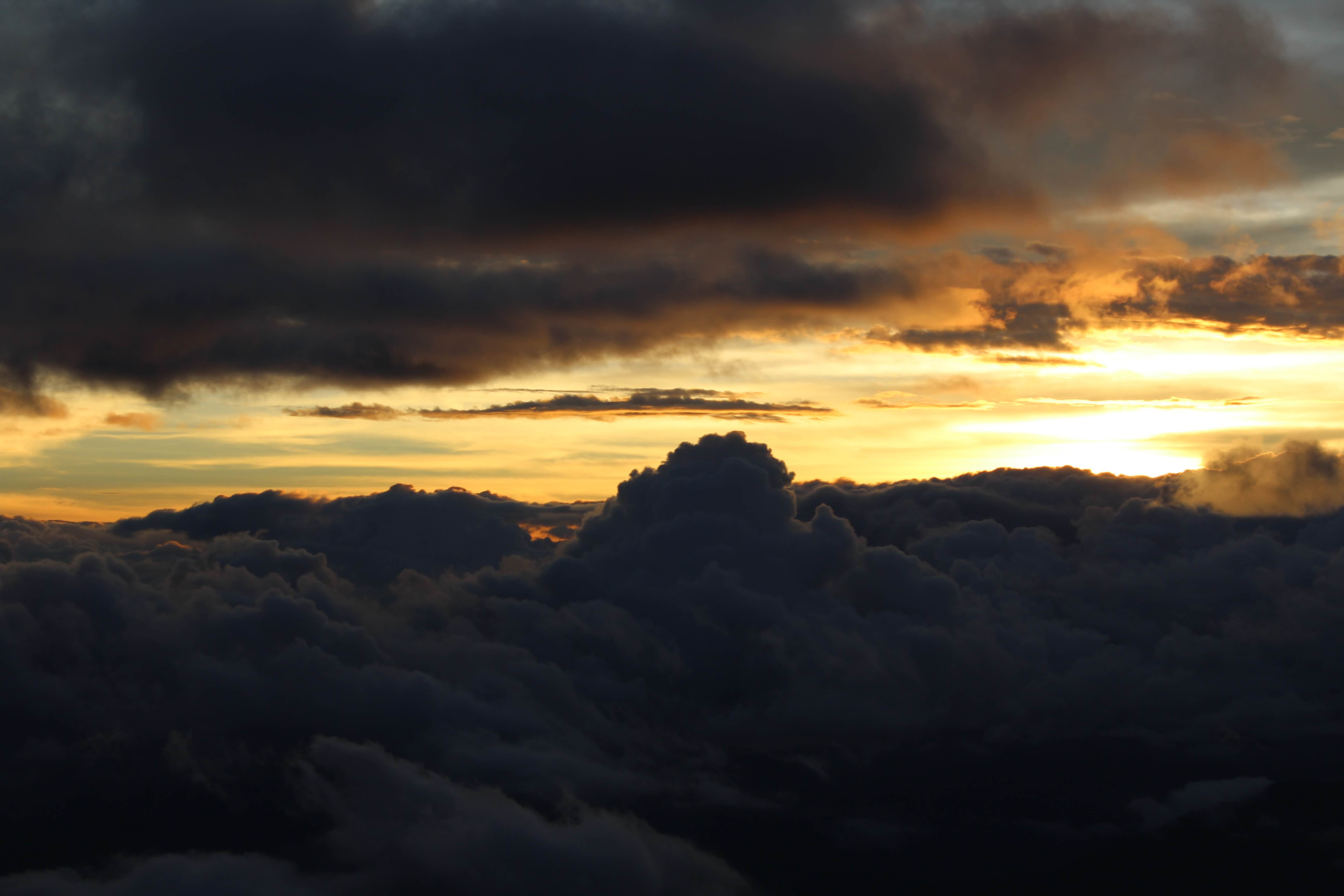
This phenomenon looks most dramatic during the early morning. The effect intensifies when the sun rises over the mountain’s grasslands and mossy forests, painting the misty expanse in vibrant shades of gold and pink. It is a visual feast that perfectly justifies Mount Pulag’s nickname, the "Playground of the Gods."
The best time to witness the sea of clouds falls during the dry season, from November to February. Cooler temperatures and lower humidity create the absolute ideal conditions. Make sure you reach the summit between 4:30 AM and 6:00 AM. Avoid the wet season (June to October), as heavy rains often obscure visibility and make the trails unsafe.
Cultural Significance of Mount Pulag
Mount Pulag is far more than a natural wonder—it serves as a sacred site deeply embedded in the cultural and spiritual fabric of the indigenous communities of the Cordillera region. Revered by the Ibaloi, Kalanguya, and Kankanaey peoples, this mountain holds a profound significance. Understanding and respecting its cultural heritage remains absolutely essential for all visitors.
A Sacred Dwelling Place
In the animistic beliefs of the local people, Mount Pulag acts as a dwelling place for ancestral spirits and deities. These indigenous groups view the mountain as a living entity. The mist-shrouded summit serves as a gateway between the physical and spiritual worlds, where elders perform rituals to seek blessings for bountiful harvests and protection. The name “Pulag” derives from the Ibaloi word “puag,” meaning “bald,” perfectly describing the grassy summit that contrasts with the forested slopes.
Sacred Rituals and Traditions
Traditional rituals form a cornerstone of Mount Pulag’s cultural identity. One notable practice is the “cañao,” a community feast and offering to the spirits. Spiritual leaders present offerings like rice wine (tapuy) and native herbs at the summit, symbolizing deep gratitude and respect. Another ritual involves the “dawak,” a healing ceremony performed to cure ailments. The mountain’s severe altitude and isolation make it a fitting location for such solemn practices.
Local guides readily share stories and traditions during hikes, offering a firsthand glimpse into this vibrant culture. By listening to your guides and avoiding disruptive behavior at sacred sites, you actively contribute to the preservation of this cultural treasure.
How to Get to Mount Pulag?
To reach Mount Pulag in 2026, start by traveling from Manila to Baguio City. A bus ride takes 4–6 hours and costs PHP 800–1,200 (USD 16–24). Alternatively, drive via major expressways like NLEX and TPLEX for roughly 4–5 hours.
From Baguio, take a jeepney or van to Jangjang Market (1–1.5 hours, PHP 50–100). Next, charter a jeepney directly to the Babadak Ranger Station (1–2 hours, PHP 2,500–3,500 round trip for a group). This serves as the jump-off point for the Ambangeg Trail. Joining an organized tour package (PHP 2000–6000) provides the most hassle-free transfers, usually including private vans that drive straight from Baguio to the Ranger Station.
Time your trip for the dry season (November to February) and start your summit trek by 3:00 AM to catch the sea of clouds at sunrise. Choose the Ambangeg Trail for a beginner-friendly 4–6 hour hike, Akiki for an expert 7–11 hour challenge, or Tawangan for a rugged 2–3 day adventure.
Prepare for freezing temperatures (5–10°C) with properly layered clothing and secure your permits early. Leverage your local guides for cultural insights, and most importantly, respect the mountain’s sacred nature by following strict Leave No Trace principles.